
Storm Alert: Cyclone Vaianu Threatens New Zealand with 140km/h Gusts and Massive 8m Sea Swells
New Zealand is currently on high alert as Cyclone Vaianu intensifies, bringing what meteorologists describe as a “life-threatening” weather event. The tropical system, moving rapidly across the Pacific, is expected to make landfall with devastating force. Residents in coastal and low-lying areas are being urged to finalize emergency preparations immediately as authorities brace for widespread infrastructure damage and power outages.
The Power of Vaianu: Winds and Waves
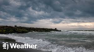
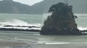
The latest satellite data indicates that Cyclone Vaianu is carrying sustained winds of up to 120km/h, with localized gusts reaching a terrifying 140km/h. This level of wind force is capable of uprooting trees, damaging residential roofing, and downing power lines across the North Island. Furthermore, maritime authorities have issued a severe warning for mariners, with wave heights expected to peak at 8 meters along the eastern coastline, creating extremely hazardous conditions for shipping and coastal properties.
Torrential Rain and Flooding Risks
Beyond the wind, the primary concern for many inland regions is the projected rainfall. Some areas are expected to receive over 200mm of rain within a 24-hour window, leading to rapid river rises and potential flash flooding. Civil Defence has already begun pre-emptive evacuations in flood-prone zones. The saturated ground from previous autumn showers increases the risk of landslides in hilly terrain, particularly across the Coromandel and Tairāwhiti regions.
Aviation and Transport Disruptions
Travel across the country is seeing significant impact. Major airports, including Auckland and Wellington, have begun cancelling domestic and international flights as crosswinds exceed safe operational limits. Commuters are advised to stay off the roads, with several key highways likely to be closed due to fallen debris or surface flooding. KiwiRail has also suspended services on vulnerable coastal tracks as a safety precaution against the surging sea levels.
Final Thoughts: Safety First
Emergency Verdict: Cyclone Vaianu is not an event to be taken lightly. The combination of high-velocity winds and extreme rainfall makes this the most significant storm of the 2026 season so far. Community resilience and following official advice will be key to navigating the next 48 hours safely.
Safety Tip: Ensure your emergency kits are ready, devices are charged, and you have a clear plan for your family and pets.
Cyclone Vaianu: Frequently Asked Questions
As of the latest update, Cyclone Vaianu is classified as a Category 2 system, with the potential to intensify further before hitting the New Zealand coast.
The highest risk areas currently include the Northland, Auckland, Coromandel Peninsula, and the Bay of Plenty, where Red Weather Warnings are in effect.
Waves are expected to reach up to 8 meters in height, leading to significant coastal erosion and the threat of sea-water inundation in low-lying areas.
Aviation and road transport are heavily disrupted. It is strongly advised to check with your airline or the Waka Kotahi NZ Transport Agency before attempting any travel.
Stay tuned to Bollywoodview.in for live updates, or follow the official MetService and National Emergency Management Agency (NEMA) channels.